Aztec boasts over 30 miles of mountain bike trails, including the Alien Run, which is ranked among the more technically challenging and scenic single tracks in the Southwest. Routed near an alleged UFO crash site, "the Alien Run" can be navigated by a novice yet is immensely challenging for experts.
Nourished by the Pine and San Juan rivers, Navajo Lake is 25 miles long with more than 200 camping and picnic sites, two improved boat ramps and a marina. Recreation includes boating, sailing and other water sports, plus trophy fishing for brown, rainbow, and cutthroat trout, largemouth bass, crappie, bluegill, channel catfish and kokanee salmon.
Flowing from Navajo Lake, the lower San Juan River is ranked among America's top-10 trout fishing waters. A 4.5-mile, nutrient-rich section below Navajo Dam is so spectacular for fishing that it has earned "Quality Waters" designation. (Special angling regulations are in effect.) Attracting sports enthusiasts the world over, the river further compels with multi-hued sandstone canyons and desert vistas.
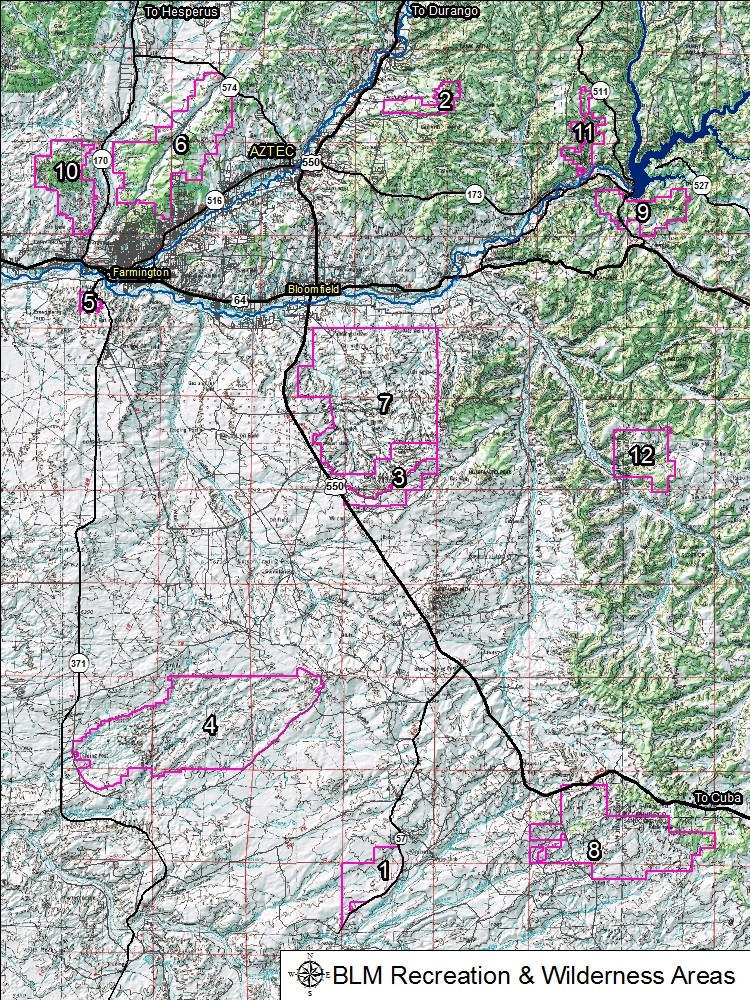
A BLM wilderness study area, "Ah-shi-sle-pah" are eroded badlands that like the Bisti offer some of the most unusual scenery in the Four Corners. Time and Mother Nature have etched a fantasy world of strange rock formations. Most commonly found in the Ah-shi-sle-pah are hoodoos, petrified logs and stumps, and fossils from the late Creteous era (dinosaur, crocodilian scutes, and turtle shell).
This 10,000-acre landscape is celebrated for its rugged and scenic wonders, including
7,000-foot Angel Peak. The river-deposited San Jose Formation sandstone is visible for miles in any direction. The banded colors of the badlands and the deep sculpted canyon fingers are fully revealed only to those who make the short journey along the rim. BLM managed, overnight camping and picnics.
A federal wilderness area, "the Bisti" are eroded badlands that offer some of the most unusual scenery in the Four Corners. Time and natural elements have etched a fantasy world of strange rock formations. Bisti (pronounced bis-tie) is Navajo for "a large area of shale hills." De-Na-Zin (deh-nah-zin) is Navajo for "cranes." Petroglyphs of cranes have been found south of the wilderness area.
Over 800 acres of fun is waiting for off-road enthusiasts at the Dunes Vehicle Recreation Area south of Farmington. The off-highway vehicle area contains a wide variety of topography including large sand dunes, steep to gentle hillsides, and sandy arroyo bottoms. Innumerable roads and trails exist in the Dunes, created by nearly 40 years of off-road vehicle use. The diverse landscape attracts a variety of motorized activity and provides riders a place to play, test their endurance, and improve their skills.
A great spot for the weekend warrior, the Glade Run Recreation Area is comprised of 19,000 acres of sandy arroyos, slick rock and rolling terrain. Vegetation is sparse, primarily consisting of common grasses, rabbitbrush, sagebrush, junipers, and pinions.
A BLM area designated as a 'Fossil Area' this area is commonly referred to as the Lybrook Badlands. This area is somewhat similar to the Bisti and Ah-shi-sle-pah Wilderness areas. It consists of extensively eroded badlands with scattered strange rock formations, banded clay domes, massive hoodoos, and fossils from the late Cretaceous era (dinosaur, crocodilian scutes, and turtle shell).
Simon Canyon Area of Critical Environmental Concern (ACEC) (#10)
Simon Canyon Area of Critical Environmental Concern (ACEC) is about 3,900 acres in size and is managed for semi-primitive forms of recreation including fishing, hiking, and backpacking. Development at the mouth of the canyon is minimal (with a parking lot, picnic table, and toilet) and provides the visitor an alternative to the more highly developed state park sites located nearby.
The wildlife in northwestern New Mexico is quite diverse within the various desert to riverine eco-systems. Various species have been photographed in the surrounding wilderness areas, canyons and river valleys present in San Juan County.