
Animas River
The Animas River (Spanish for "River of Lost Souls") is a 126 mile long river that originates from the San Juan Mountains of Colorado and feeds into the San Juan River. Provided below is a guide for rafting, kayaking or canoeing along the southern half of the Animas River, from Durango, CO to Farmington, NM.
Support river protection organizations such as River Reach (www.riverreachfoundation.com), San Juan Citizens Alliance (www.sanjuancitizens.org), Friends of the Animas, and American Whitewater. Rivers rely on dedicated support from river runners like you. Are you a member?
Support river protection organizations such as River Reach (www.riverreachfoundation.com), San Juan Citizens Alliance (www.sanjuancitizens.org), Friends of the Animas, and American Whitewater. Rivers rely on dedicated support from river runners like you. Are you a member?
General Rules
Please support rivers in Colorado and New Mexico.
• The shore and beaches are private property.
• Trespass by people (or even dogs) aggravates landowners, may disturb wildlife, and threatens access to rivers.
• Leave no trace. Carry wag bags or groovers for human waste.
• No fires.
Please support rivers in Colorado and New Mexico.
Section 1: Durango to State Line
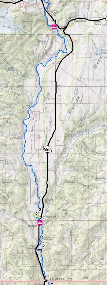
Map: 1 - RIVER ACCESS
Mile: 0
Longitude: -107.859616
Latitude: 37.221281
Dallabetta Park, Durango
Map: 2 - DANGER
Mile: 14.9
Longitude: -107.878895
Latitude: 37.058068
Undercut Rocks. Large sized undercut rocks on river left shore. Especially dangerous at flows below 1500 cfs. Scout or portage recommended. Stay on the inside of the bend (stay on river right).
Map: 3 - RIVER ACCESS
Mile: 15.7
Longitude: -107.874998
Latitude: 37.051055
550 Bridge just below Bondad Hill. Takeout river left below bridge with a short steep carry suitable for small rafts, kayaks.
Map: 4 - LANDMARK
Mile: 16.9
Longitude: -107.873509
Latitude: 37.035786
Historical Train Water Tank
This rail line was called the "Red Apple Flyer" and was in service 1905 until the 1960s.
Map: 5 - LANDMARK
Mile: 17.7
Longitude: -107.874923
Latitude: 37.027680
Historic Train Bridge
Potentially dangerous pilings.
Map: 6 - Colorado|New Mexico State Line
Mile: 19.9
Longitude: -107.866132
Latitude: 36.999737
Section 2: State Line to Aztec
Map: 7 - CAMPING
Mile: 20.1
Longitude: -107.864739
Latitude: 36.997152
Animas 1 on BLM lands.
Camp located at river left, gas compressor facility directly across on river right. This is the best public/primitive camping between Durango to Aztec.
Map: 8 - CAMPING / ACCESS
Mile: 20.7
Longitude: -107.867697
Latitude: 36.989341
Animas River RV Park
RV Park, Access and parking through permission:
Steve Layton, 970-749-2695
Map: 9 - CAUTION / DANGER
Mile: 22.2
Longitude: -107.871531
Latitude: 36.966116
Stacie Ditch Co. Diversion Dam
To avoid rebar punctures, line your boats on river left.
Map: 10 - LANDMARK
Mile: 22.4
Longitude: -107.875146
Latitude: 36.968299
Abandoned Bridge
Map: 11 - LANDMARK
Mile: 23.6
Longitude: -107.883053
Latitude: 36.955521
Bridge 2290
Map: 12 - LANDMARK
Mile: 24.4
Longitude: -107.879727
Latitude: 36.947520
Old Bridge Abutments
Map: 13 - LANDMARK
Mile: 26.3
Longitude: -107.885317
Latitude: 36.928944
Abandoned Bridge & Water Flume
Map: 14 - ACCESS / LANDMARK
Mile: 26.9
Longitude: -107.893921
Latitude: 36.933222
Cedar Hill Old 550 Bridge
Walk down river left between road and old bridges. 300 foot carry suitable for small rafts and kayaks.
Map: 15 - CAUTION / DANGER
Mile: 28.6
Longitude: -107.910114
Latitude: 36.920905
Animas Ditch Diversion,
potential rebar danger.
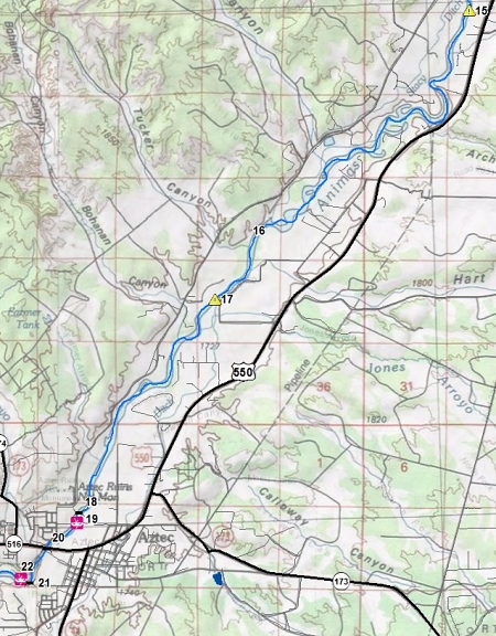
Map: 16 - CAMPING
Mile: 33.7
Longitude: -107.957542
Latitude: 36.880830
Animas 8 on BLM Land.
Map: 17 - CAUTION / DANGER
Mile: 34.6
Longitude: -107.965956
Latitude: 36.869988
Farmers Ditch Diversion Dam
Commonly run in the middle. Scrapey below 1000cfs. Dory needs 2000+.
Map: 18 - LANDMARK
Mile: 38.1
Longitude: -107.995624
Latitude: 36.832383
Aztec North Pedestrian Bridge
Map: 19 - ACCESS / PARKING
Mile: 38.2
Longitude: -107.996041
Latitude: 36.830446
City of Aztec Rio de Animas Park has access via carry or trailer and remote parking on Martinez Lane.
Map: 20 - LANDMARK
Mile: 38.7
Longitude: -108.002794
Latitude: 36.826106
550 Bridge with murals on bridge pillars.
Map: 21 - LANDMARK
Mile: 39.2
Longitude: -108.006410
Latitude: 36.820000
Aztec South Pedestrian Bridge
Map: 22 - ACCESS / PARKING
Mile: 39.4
Longitude: -108.008483
Latitude: 36.820633
City of Aztec Riverside Park
Section 3: Aztec to Farmington
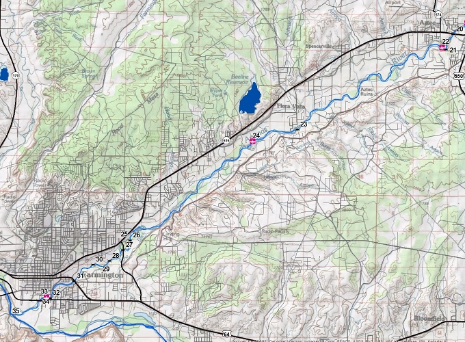
Map: 23 - LANDMARK
Mile: 45.3 / 5.9
Longitude: -108.080076
Latitude: 36.787868
Road 350 Bridge
Map: 24 - ACCESS
Mile: 46.7 / 7.3
Longitude: -108.102465
Latitude: 36.782974
Penny Lane Boat Ramp
Easy trailer friendly boat ramps available above and below dam.
Map: 25 - POINT OF INTEREST
Mile: 51.5 / 12.1
Longitude: -108.164262
Farmington Museum visible from river. However no access.
Map: 26 - LANDMARK
Mile: 51.6 / 12.2
Longitude: -108.163040
Latitude: 36.743403
Animas Park Bridge
Map: 27 - LANDMARK
Mile: 52.0 / 12.6
Longitude: -108.166582
Latitude: 36.739546
Browning Bridge
Map: 28 - LANDMARK
Mile: 52.6 / 13.1
Longitude: -108.173288
Latitude: 36.735165
Pedestrian Bridge
Map: 29 - POINT OF INTEREST
Mile: 52.8 / 13.3
Longitude: -108.176775
Latitude: 36.733291
Farmington Veterans Memorial
Map: 30 - LANDMARK
Mile: 53.1 / 13.6
Longitude: -108.181381
Latitude: 36.733590
Pedestrian Bridge
Map: 31 - LANDMARK
Mile: 53.9 / 14.4
Longitude: -108.190834
Latitude: 36.727053
US 64 Bridge
Map: 32 - LANDMARK
Mile: 54.9 / 15.4
Longitude: -108.202695
Latitude: 36.720235
Murray Drive Bridge
Map: 33 - ACCESS
Mile: 55.0 / 15.5
Longitude: -108.204597
Latitude: 36.720367
Boyd Park, trailer access possible.
Map: 34 - LANDMARK
Mile: 55.2 / 15.7
Longitude: -108.208269
Latitude: 36.719153
US 64 Bridge
Map: 35 - SAN JUAN RIVER
Mile: 56.1 / 16.6
Longitude: -108.221450
Latitude: 36.713474
Confluence of Animas River with San Juan River. Next landing is at Kirtland Lions Park approximately 7.7 miles.