
Southwest Colorado Mountain Bike Trails
Colorado is one of the world's premier mountain biking destinations. Within the Southwest region of Colorado, are numerous trails for the beginners to the experts. The scenery is amazing with colorful landscapes ranging from high desert to scenic valleys, and high mountains.
 Difficulty of trails is based on riders' experience and input on the MTB Project, a REI Co-Op program.
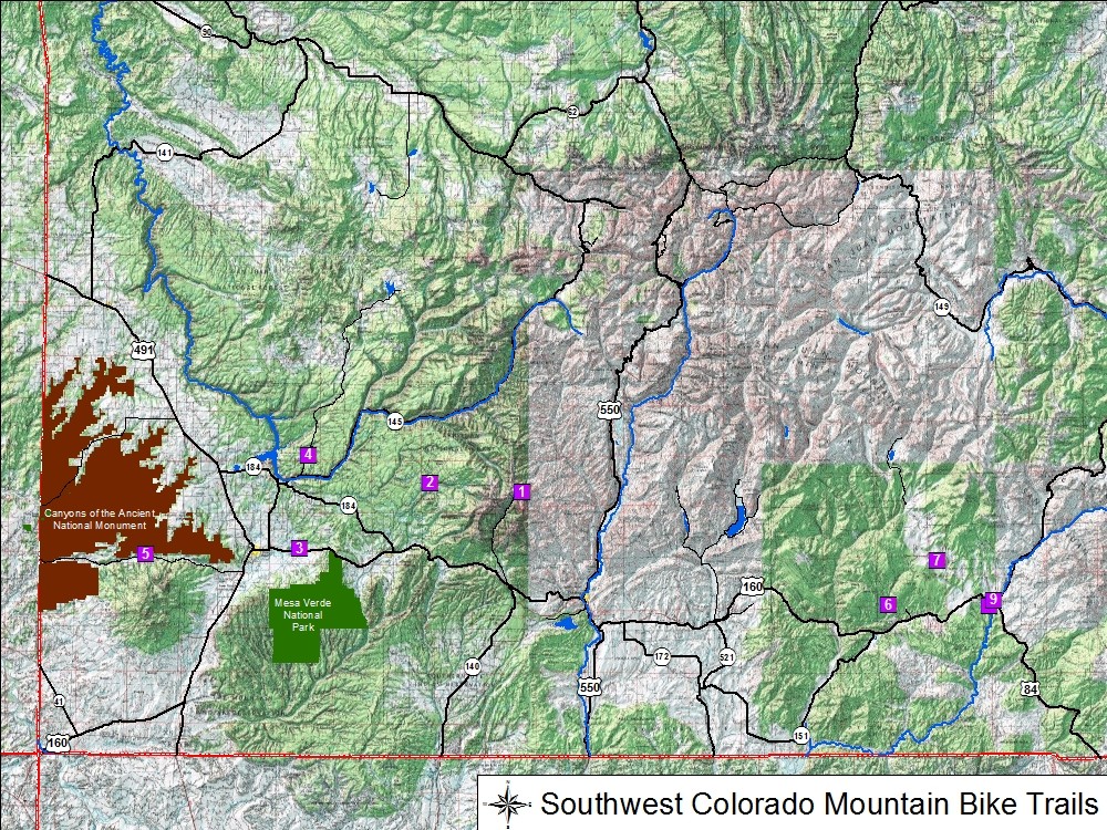
➠ Southwest Colorado Mountain Bike Trails Map (PDF 290 KB)
Cortez Area
Canyons of the Ancients System
Trail Name Difficulty Miles East Rock Creek Trail Intermediate / Difficult 5.1 Sand Canyon Trail Intermediate / Difficult 3.6 ⇩ Canyons of the Ancients Trails Info (PDF 80 KB) ⇩ Canyons of the Ancients Trails Map (PDF 246 KB) ⇩ GPX File (ZIP 12 KB)
Phil's World System
Trail Name Difficulty Miles 2-More Loop Intermediate 2.1 Hippie House Easy / Intermediate 2.7 Ledges Loop Intermediate / Difficult 5.0 Main Loop Intermediate 10.8 Stinking Springs Loop Intermediate / Difficult 5.5 Trust Loop Easy / Intermediate 3.5 ⇩ Phil's World Trails Info (PDF 85 KB) ⇩ Phil's World Trails Map (PDF 211 KB) ⇩ GPX File (ZIP 34 KB)
Dolores Area
Boggy Draw System
Trail Name Difficulty Miles Boggy Draw Loop Easy / Intermediate 8.4 Italian Canyon Trail Intermediate 5.8 Little Bean Canyon Trail Intermediate 11.4 Mavericks Trail Easy / Intermediate 5.2 ⇩ Boggy Draw Trails Info (PDF 95 KB) ⇩ Boggy Draw Trails Map (PDF 213 KB) ⇩ GPX File (ZIP 35 KB)
Hesperus-La Plata Area
La Plata Mountains System
Trail Name Difficulty Miles Bear Creek to Sharkstooth Difficult 18.2 Sharkstooth Trail Extreme Difficulty 7.4 ⇩ La Plata Mountains Trails Info (PDF 73 KB) ⇩ La Plata Mountains Trails Map (PDF 255 KB) ⇩ GPX File (ZIP 18 KB)
Mancos Area
Mancos State Park System
Trail Name Difficulty Miles Black Bear Trail Easy / Intermediate 1.4 Chicken Creek Trail Intermediate / Difficult 7.5 ⇩ Mancos State Park & San Juan National Forest Trails Info (PDF 78 KB) ⇩ Mancos State Park & San Juan National Forest Trails Map (PDF 2394 KB) ⇩ GPX File (ZIP 14 KB)
San Juan National Forest System
Trail Name Difficulty Miles Mancos Box Canyon Trail Difficult 6.3 Mancos Rim Trail Intermediate / Difficult 1.2 West Mancos Trail Difficult 4.0 ⇩ Mancos State Park & San Juan National Forest Trails Info (PDF 78 KB) ⇩ Mancos State Park & San Juan National Forest Trails Map (PDF 239 KB) ⇩ GPX File (ZIP 14 KB)
Pagosa Springs Area
Dakota Springs System
Trail Name Difficulty Miles Dust 2 Connector Easy 0.4 Flow My Mind Intermediate 0.2 School of Rock Difficult 0.2 Super D Easy 1.5 ⇩ Dakota Springs Trails Info (PDF 76 KB) ⇩ Dakota Springs Trails Map (PDF 126 KB) ⇩ GPX File (ZIP 3 KB)
Devil Mountain System
Trail Name Difficulty Miles Beaver Lakes Intermediate / Difficult 4.0 Devil Mountain Trail Difficulty 4.3 Double G Intermediate 4.0 Snow Ranch C Intermediate 3.8 Snow Springs Intermediate / Difficult 4.9 ⇩ Devil Mountain Trails Info (PDF 74 KB) ⇩ Devil Mountain Trails Map (PDF 197 KB) ⇩ GPX File (ZIP 12 KB)
Pagosa System
Trail Name Difficulty Miles Aspen Run Trail Easy / Intermediate 2.2 Brockover Easy 1.5 Catamount Easy / Intermediate 5.2 Coyote Hill Loop Intermediate 3.3 Gopher Easy / Intermediate 6.5 Lower Rim Intermediate 2.4 Newt Jack Easy / Intermediate 1.9 Park Ave Easy / Intermediate 1.4 Powerline Intermediate / Difficult 2.9 Quakie Spring Difficult 1.7 Round Park Easy / Intermediate 3.2 Turkey Springs Easy / Intermediate 3.6 Upper Rim Easy / Intermediate 3.8 Turkey Springs Outer Loop
(Combination of several trails)Easy / Intermediate 15.3 ⇩ Pagosa Trails Info (PDF 98 KB) ⇩ Pagosa Trails Map (PDF 206 KB) ⇩ GPX File (ZIP 29 KB)
Reservation Hill System
Trail Name Difficulty Miles Bankshot Intermediate / Difficult 0.2 Bronco Trail Intermediate 0.4 Buena Vista Intermediate 0.3 Connector Easy 0.2 Crosscut Difficult 0.4 FreeRide Difficult 0.2 Greenhorn Easy / Intermediate 0.2 Rosebud Intermediate 0.2 Skyrocket Intermediate 0.7 Tecolote Loop Easy 1.1 Tenderfoot Easy / Intermediate 0.5 Terry Smith Loop Easy 0.4 Wapiti Intermediate 0.4 ⇩ Reservoir Hill Trails Info (PDF 86 KB) ⇩ Reservoir Hill Trails Map (PDF 156 KB) ⇩ GPX File (ZIP 7 KB)