Canyon de Chelly National Monument, AZ
North Rim Scenic Drive
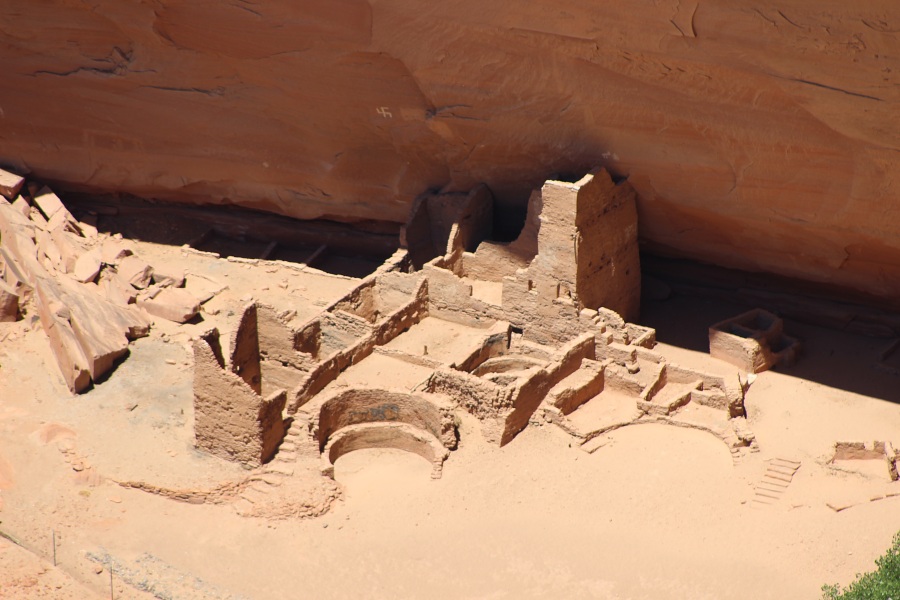
Antelope House Ruin Overlook
There is a quarter-mile rocky trail that divides to reach viewpoints of Antelope House Ruin (to the right) and Navajo Fortress (to the left). Antelope House or Jadi dayi jeehi, Navajo for "running antelope" was named after the finely executed historic and prehistoric paintings of antelope on the canyon wall to the left of the ruin. Local Navajo attribute the historic paintings of antelope, in several colors, to Dibe Yazhi (Little Sheep), a highly respected Navajo artist who lived here in the 1830s. The prehistoric Puebloan occupants of Antelope House had earlier created hand outlines and antelope in white paint.
A late Basketmaker period pit house, found by archeologists in the 1970s under the surface masonry structure of Antelope House, dates back to CE 693. The site was occupied fairly continuously after that time and consists of two major room blocks connected by a circular central plaza. This is the only site in the canyon to have such a plaza. The circular rooms are kivas, while the rectangular rooms are either used for storage or living quarters. This three-to four-story pueblo contains more than eighty rooms and remains of at least seven kivas. It is at least four stories high in places. Archeologists determined the site to be largely unoccupied by about CE 1275. Excessive rains and violent flooding are speculated to have been factors that ended the occupation of this site.
Navajo Fortress Viewpoint
Navajo Fortress, the isolated high redstone butte located across the canyon, was once an important Navajo refuge from raiders: Spanish, American, and other native tribes.
Archeologists believe that the Navajo initially moved into the American Southwest sometime between CE 1300 and 1500, moving south from the Pacific Northwest. At this time they were nomadic, hunting and gathering as they moved. Contact with the pueblo tribes along the Rio Grande and also with the Spaniards in the sixteenth and seventeenth centuries resulted in the introduction of agriculture, weaving, and sheep herding to the Navajo. Canyon de Chelly's earliest identifiable Navajo remains date back to mid-eighteenth century; however, Spanish documents suggest that Navajos were in the area before that time.
Navajo Fortress was used as a refuge throughout the period of Spanish and American military actions against the Navajo people. On the east side, but not visible from the overlook, is a trail leading to the top of the fortress from the canyon floor. At a number of places, log poles that were used to connect the lower levels with otherwise inaccessible sections directly above still stand. As the Navajos climbed, they pulled the poles up behind them, effectively cutting off access for enemies. Also located at strategic spots are small rock walls behind which retreating Navajos hid from and attacked any intruders attempting to follow.
Fortress Rock was an especially crucial refuge during Colonel Kit Carson's crusade to remove Navajos from their homeland. Carson's men destroyed cornfields, homes, and livestock during sporadic offenses in 1863. In the winter of 1864, he struck Canyon de Chelly directly. Hundreds of Navajos took shelter atop Fortress Rock; however, a sizeable portion of the Navajo population, lacking sufficient supplies and shelter, surrendered. Those who did so were forced to walk to Fort Sumner (Bosque Redondo), New Mexico nearly 400 miles away. Disease, drought, and severe weather made living conditions impossible at Fort Sumner. Finally, in 1868, the Navajos were allowed to return to their homelands within a new reservation that included Canyon de Chelly. This traumatic event, known as the Long Walk, endures in the memory and stories of many Navajo people today. Since the Carson campaign, the Navajo people have not used the fortress.
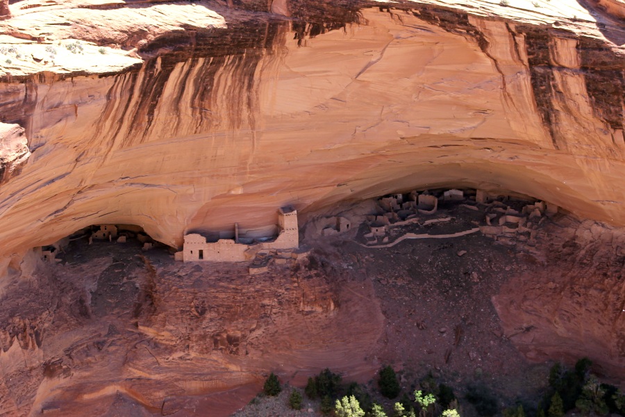
Mummy Cave Overlook
One of the largest and most beautiful ruins within Canyon del Muerto is Mummy Cave or Tse yaa Kini, Navajo for "house under the rock." Archeologists uncovered evidence of continuous habitation at this site from the time of earliest known occupation of the canyon to the latest dates of permanent residence by ancient Pueblo people (approximately CE 300-1300). This dwelling is built in two adjacent caves several hundred feet above the streambed. The largest portion of the settlement is in the eastern alcove and includes four kivas and more than fifty rooms. The western cave contains about twenty rooms. As houses on the lower levels became buried under debris, others were built on top of them and the locations were reoccupied.
Constructed after the alcove structures, the central portion includes seven rooms and a three-story tower. Tree-ring dating techniques indicate the tower unit was built about CE 1286. This central unit has been identified as Mesa Verde-type masonry and is thought to have been built by people migrating from the Mesa Verde area late in the Pueblo occupation. It is not known whether the tower structure was used primarily as a defensive outpost or had special ceremonial significance. Throughout this ruin, much of the original plaster used on the walls remains. Mummy Cave received its name when an archeological expedition into the canyon in the late 1880s found two mummies in cists eroding out of the talus slope below the site. The leader of the expedition, Colonel James Stevenson, gave Canyon del Muerto its name following his work at Mummy Cave.
Massacre Cave Overlook
There are two viewpoints at this overlook. The first will show you Massacre Cave. A battle took place at the rock-strewn ledge located to the left under the canyon rim overhang. In 1805, Antonio de Narbona led a Spanish military expedition into Canyon de Chelly hoping to put an end to disputes over Spanish settlements expanding into Navajo country. Narbona reported that his forces killed as many as 115 Navajo people taking refuge in the canyon and 33 were taken captive. At the time most of the able-bodied Navajo men were away hunting. The women, children, and elderly people, seeing a raiding party composed of Spaniards and Opata Indians, fled and hid in the cave. The cave, located high up the nearly 1000-foot canyon wall, was difficult to see from below. Fallen rocks along the narrow ledge provided shelter. There are many different accounts of what happened next.
Navajos call the site "Ah dah aho nili or" the place where two fell off; referring to the story of a Navajo woman struggling with a Spanish soldier who fell from the ledge with her. Regardless of what really happened, the results were tragic. The troops fired shots into the cave causing bullets to ricochet off the cave walls. This killed many of the Navajos. The battle at Massacre Cave is one of the few reported confrontations between Spanish troops and the Navajos of Canyon de Chelly, but is a sad mark on the history of this beautiful canyon.
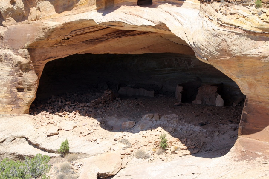
Yucca Cave Viewpoint
Yucca Cave was occupied in the Basketmaker, Pueblo, and Historic periods. The cluster of structures in the alcove includes four definite rooms, one kiva, and two other possible rooms. The single smaller structure tucked inside a sandstone pocket to the left of the main alcove was used for food storage in prehistoric times. Though not visible from this overlook, a hand-and-toehold trail connects the two alcoves.